by The Weather Gage » Thu Feb 25, 2010 9:07 pm
Notes on Geography
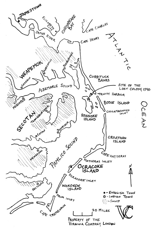
Ocracoke Island is part of a chain of islands common called the Outer Banks. These barrier islands are low and sandy, with shallow soil that lends itself to tough grass, scraggly bushes and pine trees. Ocracoke is one of the few islands with natural wells and fresh water, making it key in the Virginia Company's plans to economically exploit the area.
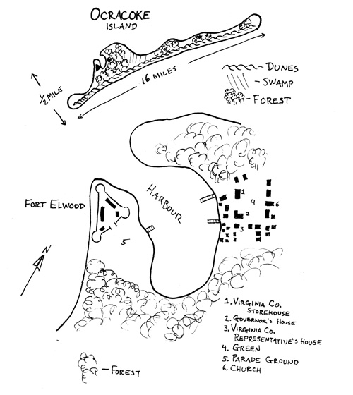
Ocracoke, is on average only five feet above sea level, except for its sand dunes, some of which can be 100 feet high but most are only twenty to fifty. These sand dunes provide the island protection from violent storms. They are covered in sea oats and line the island's Atlantic coast
Summer is generally hurricane season and the Company avoids dispatching ships that will make landfall at Ocracoke around that time. Winter to early spring can sometimes witness Nor'easters, violent and cold rain storms. Aside from these events, Ocracoke has a temperate climate, with the Gulf Stream keeping the island mild in winter, and moderate in the summer. January tends to be the coolest month (54 to 38 F), and August the hottest (85 to 72 F).
In addition, the large, ocean-going ships in the Company's merchant marine tend to use Ocracoke Inlet and occasionally Hatteras Inlet to access the town's harbour. Due to the nature of the banks, shoals (shallow water) around the Outer Banks' other inlets are constantly shifting, making the more narrower inlets very dangerous. The waters around Capes Hatteras and Tremendum are also dangerous, with shoals stretching far out to sea. Mariners have begun to nickname Cape Hatteras in particular the Diamond Shoals for its ability to cut open the bottom of ships.
Animals on the island include ducks, squirrels, rabbits, and "Banks Deer." Banks deer closely resemble their mainland family, but due to poor quality grass on the island, remain small, lean, and few. The ducks are generally most plentiful when they migrate in spring and fall. Most food for the island is sometimes imported (beer, wine, and the like), but most often is fished out of the ocean or out of Pamlico Sound. The sound is rich with fish, including large sturgeon and trout, as well as crabs, clams, and oysters. In a word, so long as you can fish, there is no reason to starve on Ocracoke!
There are no Indians on Ocracoke Island. The Natives live on the mainland are part of either the Secotan or Weapemok tribes, both of which speak Algonquin. Their towns are semi-permanent and the natives generally live in smaller camps in the fall and winter to live off oysters and crabs on the many inlets and rivers that lead to Pamlico Sound. The Indians sometimes visit Ocracoke to trade, but are generally wary of the English and keep to themselves.
Notes on Ocracoke Town
Ocracoke Town was founded by Governor George Elwood in spring 1609. Being that the town is so young, all of the buildings are of wood construction, including the fort, which consists of wooden palisades and dirt-filled redoubts. Only two buildings have brick in them, and those are the Governor's house and the Virginia Company Representative's house. And even on these houses, the brick was used to build chimneys. There is some natural clay on the island, so there is the opportunity to build brick buildings on the island, but for the most part, everyone lives in wattle-and-daub huts or clapboard cottages. The largest buildings on the island are the Governor's House, the Church, and the barracks in the Fort. However, these are only large by Ocracoke's standards and are rather humble and utilitarian. Only the very rich (ie. the Governor or the VC representative) are able to bring furniture to the island, everything else is made on site.
The nearest post of company authority outside Ocracoke is in Virginia's Capital, Jamestown, which is approximatley a week or so away by boat, depending on how the currents are moving and the wind is blowing.
If there is any further questions about the geography of the Virginia Company's newest settlement, feel free to send a private message to The Weather Gage!